Tuesday, 5 August 2014

Day 85 - Faroes - day 1


Day 85 Faroe Isles

Before this trip I didn’t know much about the Faroes other than a Specsavers TV ad filmed where the old sheep shearer shears his collie instead of one of his sheep.....and fish.

The Faroes are made up of many islands (15 of which are inhabited) just as our Orkneys and Shetland isles are and they are also of a similar size. The climate is pretty much the same  if not a little wetter, they have their own language and they share their currency with Denmark. Their nearest neighbours are Shetland but it is their remoteness and small size that really characterises them as does their landscape.

The van at the head of the Fjord
The mists cling to the high ground much of the time and it is home to the highest sea cliff in the world – 750m vertically straight into the ocean. But what is very much different from our own remote Scottish islands is the massive investment they have put in to their infrastructure.

There is very little farm land, the islands are all steep sided, stepped and soil coverage is thin. They struggled to find a large enough flat area low enough to put an airport on and have settled for a site which they have had to build out on at both ends to get a decent length of runway on. However each fjord and inlet, of which there are many, has a harbour and each harbour, without exception,  has fishing boats both big and small and it is their income from fish that keeps the islands prosperous.

Over the last 40 years they have progressively interconnected their islands with tunnels or causeways and connected up remote village after remote village with tunnels. I just can’t imagine us ever building a 1.5 Km tunnel though a mountain to connect up a hamlet of 15 houses and 40 inhabitants, nor building 4 tunnels of a total length of 7 Km to a village of 30 houses. They have aggressively tackled depopulation such that it is not an issue; the bonus for us as visitors is that we get to really see all around the islands and it is a real treat to enjoy.  
Faroes - Fish in water, sheep on land
The drunk sat in his boat
After our 4;30 am bed it is a struggle to get everyone up. The sun is up and I walk around the fjord to a small harbour where I am surprised by a greeting from a fisherman who is sat in a boat. He speaks no English and although it is only 08:00 a.m. he offers me a drink from his bottle of wine -  I politely decline and then we have some sort of conversation about fishing and camping before I make my way back to the van.


We spend the day making our way slowly north and east heading to Vidoy to find a place to stay. We stop for the best ‘coffee and cake’ in someone’s front room in Erdi, waffles and apple cake, jugs of coffee and tea, meringues and an invite into their own bathroom as the ‘cafe’ toilet.....it also had our 1st wifi for a while which went down well.


Coffee and cakes in someone's dining room
Over the hill we stop off at Gjogv and walk down to the sea. All Faroese villages and towns have some multi coloured wooden houses, some of which have turf roofs and Gjogv is a perhaps one of their best examples. 

Gyogv - picture perfect 

The seas are big – cliffs and massive waves are all around and Gjogv is pretty  typical of many of the small places where the effort and risk out in to fishing is something to be admired. Harbours constructed in the most difficult of places most of which with steep winch ramps to get the boats in and out of the water.


We move on through a 7 Km undersea tunnel to the eastern isles and at the most northerly tip of the whole island group, on a road to nowhere, we find a top spot for the van. The view is the wild seas and it in all directions but south

Jack on the BBQ
It is then that I read in my tourist info material that camping outside of campsites is strictly forbidden on the Faroes....a minute later a bloke mysteriously appears from nowhere, loiters for a while, rings someone and then returns. We expect a full turn out of the locals, the neighbourhood watch or the police but it all comes to nothing.


Day 85 Kaldbakstobotnur (Fo) to Vidareidi ( Fo)     158 Km     Total  12294 Km


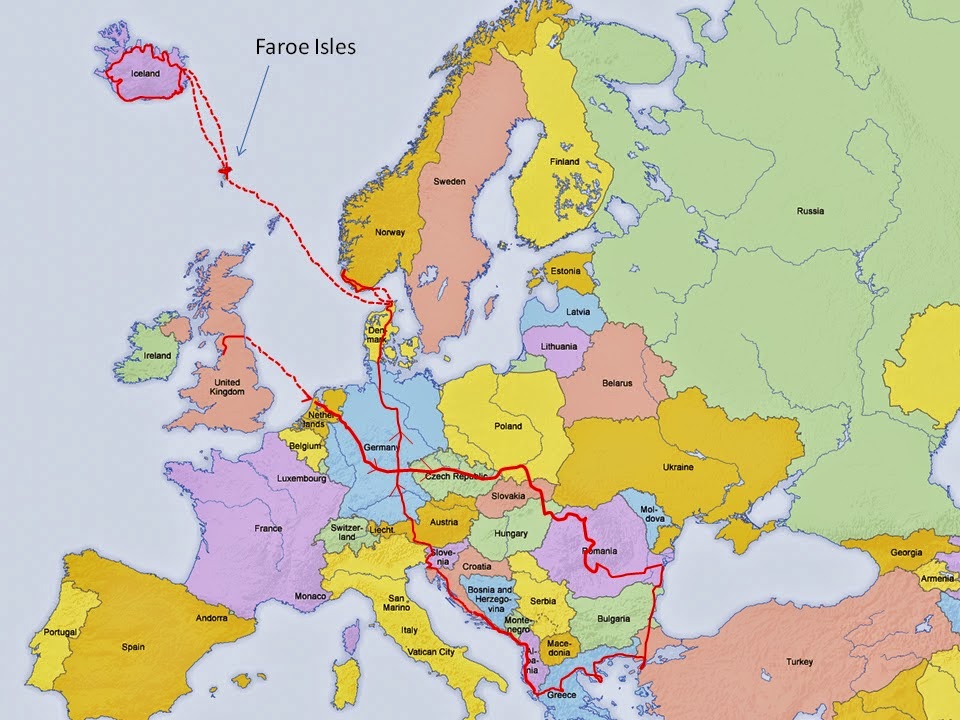
Day 83 & 84 Iceland - back to where we started 14 days ago and onto the ferry to the Faroe Islands


Day 83 A difficult drive with a hangover

Sunrise at 3 am

3 hours later at 7am

a long shadow
We all sit out until 2 a.m. feeding the fire with driftwood. Susan and Katie go to bed and Jack and I stay out determined to see the sun rise. I awake by chance an hour later, drag Jack in his sleeping bag on his 2 chairs away from the still burning fire, and then watch the sun come up before falling back to sleep again outside.

Sunrise on the glacier
We continue our journey eastwards along the south coast but we are all pretty knackered from the late night before. The sun is up and the views from the van are fantastic but the drive is a real battle. The wind is ferocious and particularly vicious when it is coming from the side. 

The van is difficult enough to drive in a straight line even with a minor cross wind as there is so much play in the steering.  On these roads the problem comes when another large vehicle comes from the other direction  - the van veers suddenly towards the centre of the road and then the wind picks it up and throws it back over, all accompanied by manic steering wheel movement from myself.

I was wrong about the Island ring road all being surfaced; on the eastern side there are some sections still without tarmac, although it is pretty good for a dirt road, pot hole free and good for 40 mph  We eventually leave the coast road and opt for the gravel mountain pass road shortcut over and down to Egilsstadhir. The track is pot holed in sections and requires the van to crawl up some 1 in 5 hill sections in 1st gear but it cuts off 65 Km of coastal drive on the main ring road.


Back in Seydisfjordur - awaiting tomorrow's ferry
We find ourselves back where we were 13 days ago and 25 Km later we are back in Seydisfjordur ( the ferry port) camping up a dirt road on the far side of town.

Our 2 weeks in Iceland is over and it has been the very very best of times. It has far outweighed my expectations which were already pretty high and I leave knowing that I will be back again sometime with still vast areas of the country not visited and enjoyed, or even just driven through.


Day 84 Ferry to Faroes, an early start and very late to bed

Unloading and loading the ‘Norrona’ takes 3 hours. The turn round time is so long partly because it only loads from the rear and so lots of vehicles have to badly execute their 3 point turns on the car deck plus they do really cram the vehicles in. Passengers have to board separately and getting out once parked is non too easy. Check-in was at 9:30 am but it was 3 hours later when I got into the cabin and everyone was already back in bed.

The sun was out and Susan and I sat on deck having some beers in the sunshine before going to the 'gorge as much as you can humanely eat' buffet tea. Bed early at 9 pm I don’t think any of us really slept, other than Charlie, as we were turfed out of our cabin at 1 a.m. ready to get off in the Faroes at 03:00 a.m.

It was darker than I expected when we rolled off the ferry in Torshavn. I had looked on the map before for a likely area to park up off the main road and 12 Km later we were there and it was spot on. We are now well practised and 10 minutes after parking up, the tent was up and loaded with all our stuff, the van empty of all our gear and all 5 of us were in bed in the van.


4:30 am and time for bed as it is getting light

Katie’s blog entry:

Sat on the ferry we all now look at the advertisements on the walls in a different light – we’ve done or seen most of what is on show, and can name most of what we see. It’s fair to say that it has been amazing – the once in a lifetime trip it was always meant to be and more, with memories that will never be forgotten. Of all the things we did I can still say that the second to last night was top on my list. We had the vast expanse of a south coast beach on one side, with the glacier tumbling down to meet barren land on the other. Watching the sunset was sensational, as was washing up the next morning in a stagnant pool of water that contained hundreds of tiny stickleback fish which could be caught with bare hands, a spoon or a mug. It was a night I will never forget.


Day 83 Jokulsarlon (I) to Seydisfjordur(I)                339 Km    Total 12124 Km  

Day 84 Seydisfjordur (I) to Kladbakstobotnur ( Fo) 10 Km     Total 12134 Km

Monday, 4 August 2014

Day 82 Iceland - Icebergs, glaciers, a boat trip and the perfect camping spot


Day 82 Iceland - Icebergs, glaciers, a boat trip and the perfect camping spot


No colour enhancement  - as it was 
The rain had cleared up overnight and with everyone asleep I climbed up out of the valley and took a path on and up towards the glacier – after an hour of half running and walking I turned still a couple of Km short of the ice. Always easier to appreciate where you are when you are coming back down rather than climbing up; it’s a  vast landscape compared to our own in England.....mile after mile of valley, glacier and mountains.

J and K trying to kill themselves
We packed and then all took a short walk before getting away and down the track just before midday. 
Huge huge alluvial plains 

The next 160 Km was a stunning drive passing small farms tucked under the cliffs and then moving on to long sections of straight road through a mixture of vast lava fields and alluvial plains.

Jack lying on the spongy lichen covered lava fields

There are many bridges, all single span with passing places on the long ones, that cross grey silt filled rivers in full flow.


As we moved further east the glacial fingers from the huge 100 Km wide Vatnajokull glacier creep almost down to the main road.


C at his 1st glacier
We take a number of dirt track detours to go and see them properly before arriving at 6 pm at Jokulsarlon.. 

The lake at Jokulsarlon is famed for having been used in 2 James Bond films and it is fairly obvious why when you get to see it.

It is pretty much a circular lake about 6km across and it is growing by 100m every year, global warming in action.
Ice on the beach
At one side the glacier ends its journey breaking off and falling into the lake to form thousands of icebergs that break up and slowly melt.

bergs floating off to sea
For a few, they manage to float across to the exit of the lake; blue, black and white icebergs of all different shapes and sizes fill the lake. Just 400m from the exit of the lake is the sea and a 40 m wide channel connects it to the sea, on an ebbing tide the icebergs flow out into the sea. Some are washed back on the nearby shore for what is a very odd but beautiful sight

We get the last but one tour onto the lake in a land/sea vehicle. Each boat has a ‘spotter’ in a RIB who finds an iceberg free route by going directly in front of our boat or alternatively, makes and ice free route by using his small boat to push an iceberg out of the way.

Susan's head on another's body
The bergs only show their top 10% above the surface and so it is the bottom 90% that they are worried about and even with the ‘spotter’ our boat hits some pretty crunching big lumps. They hand around an 800 year old lump of pure ice and all in all its a damn good trip.

K's shovel hands sneak in
 No padded suits this time as per the whale watching but a proper life jacket is provided for all.

There are seals in the channel to the sea and the arctic terns are continuously diving so the fish pickings must be rich. We make our way down to where the lake flows into the sea and we spend some time on the beach watching the breakers roll and break the huge lumps of ice up on the tide line.

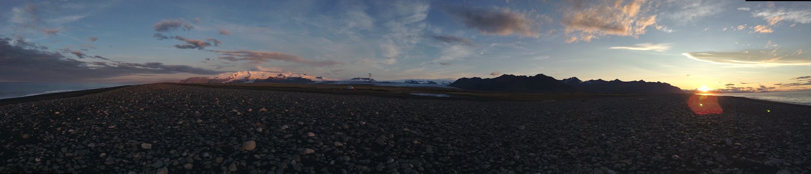
5 minutes down the road and we turn off on a track that leads to the back of the beach. We are miles from anyone or anything. There is no wind, the sun is setting over the glacier and it’s pretty much perfect....


Day 82 Paglir (I) to Jojulsarlon (I)    166 Km      Total  11785 Km


Day 81 Massive seas, driving in a cloud and a campsite in the middle of nowhere


Day 81 Massive seas, driving in a cloud and a campsite in the middle of nowhere

K walking behind the waterfall - cool
We packed and left the comfort of the lodge just as the rain started. We now have 3 nights back in the van before catching the ferry back for a 3 night stop-over in the Faroe Islands on Thursday morning. The forecast was grim with both wind and rain as we rejoined our anti-clockwise circuit of Iceland making our way down past some huge waterfalls towards its most southerly point.

I had lost £150 worth of Icelandic Kroner somewhere when we had been at the lodge so we took a small detour and called in at the shop we had visited a couple of days before on the off chance they had had it handed in. To my joy they had, fumbling old man that I am I had dropped them by the counter and someone had handed them over – a good start to the day J

The sea was wild when we go there – heavy dark grey black skies, black sand beaches and high cliffs, arches, seas stacks and basalt formations made for a spectacular sight. The waves were massive and we stood and watched them for ages, the rain having let up enough for us to stop at a few places on the coast.

The south of Iceland is quite different from the north – It gets more rain/snow and it is home to most of its glaciers. They spill down towards the coast and as it is an area of regular volcanic activity this causes the road builders some challenges. The heat from a volcanic eruption causes huge volumes of water to be generated under the ice – the water eventually finds its way out and usually does suddenly with tens’s of thousands of cubic metres or water per second pouring out and down the vast alluvial places – some many Km wide. The island ring road ( route 1) is built across this and regularly has sections washed away.

K and J up high on the basalt columns
As the years have passed the civil engineering has become more and more grand. Huge levees are built to attempt to channel the water to minimise any damage. The bridges are the hardest structures to rebuild quickly and so they try to ‘protect’ them from washing away by building sacrificial channels to either side to take the pressure off the structure in times of huge flood. We drove on a long brand new section of road and bridges built following the 2010 Eyjafjallajokul eruption that grounded thousands of flights in the northern hemisphere ...the pictures of the damage caused by the massive flood of silt, rocks, mud and ice shows that their isn’t a cat in hells chance of completely engineering their way out of this regular problem.

There was another section we crossed, a near straight 28 km section that in 1996 over 6 Km disappeared and 5 Km was severely damaged following a nearby volcano under the ice. They have left some massive twisted bridge steel girders stuck in the ground as a reminder to all of just what can and does happen.
The consequences of losing a section are significant – it’s difficult to imagine as we have so many roads that there is always another route to be found and it is generally fairly easy, perhaps a few miles deviation....Not so in Iceland, there is only the one road round the island so it means that anywhere beyond the loss of road section can only be accessed by going ¾ the way round the island in the other direction – a 600 mile journey instead of a 150 mile one. If 2 sections are lost, as they more than often are then the area between is islanded.

More messing about on the beach and then late in the afternoon it was time to find a place to stay.

We had seen an advert for a campsite near the small town of Vik so after stocking up on food we  took a climbing gravel road up into the mountains to find it. Within a couple of minutes we were driving inside the cloud with the rain coming down but it was another 17 Km later, a lot more than expected, that we finally turned a corner into a small area of flat land enclosed on all sides by steep cliffs created of weird and wonderful lava formations.

A better 'pukka' camp ground would be hard to find
The rain was persistent so we put the ‘sun shade’ up – a large canopy bought to protect us from the Greek sun but equally useful as a large rain cover...5 in the van, whilst cooking etc is nigh on impossible. The hairdryer was deployed to dry the chairs out that sit open to the elements on the roof rack all day but it was cold and as soon as we had eaten, Charlie got into his hammock and the rest of us shut the van door and got the cards out.


Day 81 Geysir ( I) to Paglir ( I)          234 Km      Total 11619 Km